Behind the scenes
WKCD asked Jay Vavra, biology teacher on the High Tech High teaching team for the project Perspectives of the San Diego Bay: A Field Guide, to unpack the project for other teachers who might want to try something similar. Vavra's fellow team members were Tom Fehrenbacher (humanities) and Rod Buenviaje (math).
Connecting with urban ecology
[A] driving force behind this project is to get today's kids in touch with nature. Whether you do it at a lake or a river or a mudflat, if students can go out and get wet and dirty and touch some living creatures, there's great learning and development that can take place. Someone has written about the "nature deficit syndrome" in our youth, and a project like this is one approach to reduce that deficit. There's a lot you can do just with some PVC and a rope. In our case, we also produced something very useful for the community, for policy makers, on understanding our local environment and how humans have disturbed it and what solutions can be taken to improve it.
Depending on where you are, this type of urban ecology study can have great relevance. The region of shore we studied is under review for remediation by the city. Our book has several sections on different sources of disturbance and what can be done to alleviate or alter those. It's a baseline measurement, and it's important to know what creatures are there, before the city undergoes great change and modifies this part of the city.
Of course, the fact that the San Diego Bay is in High Tech High's back yard, so that we can walk right off this campus and be exposed to it, is what has made this project both possible and exciting. Many schools near comparable natural resources-perhaps a wetland or a stream or a forest-and could make them part of the curriculum, a place where students can touch and observe nature and let it get under their skin.
Over three months, we made nine field trips to the Bay. We divided up the students, with half doing their reflective writing and the other half doing their intertidal surveys. Each trip took three to four hours, during the school day, with the hours depending on the tides and the school's daily schedule.
We had to time our field excursions with the heavenly bodies and the tides, because we could only go out there when these creatures are available to see, at an extreme low tide, every two weeks. And we could only choose the ones during the school day, which is difficult with our calendars.
Developing multiple perspectives
A major thread through this whole project is perspective. As they looked at the Bay and represented it, the perspective that each group took was unique, and also the tools they used to create the maps. We had a few students with experience using the Geographic Information System (GIS), linking geographic information with descriptive information in digitized layers. A group of geography and computer science professors from San Diego State and Mesa College received a three-year National Science Foundation grant to implement GIS education into San Diego city schools. After hearing about our work last year, they selected ours as a model study to teach high school teachers how to use GIS in the classroom. They came here and helped train our students how to use GIS, they went on one of our field excursions, and they are assisting in producing maps for us.
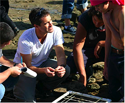
We would go out to the shore at these designated locations, and using GPS units we would record the exact coordinates of the transects—where they're aligned perpendicular to the shore. Working in teams of three, students would begin from the mean low-low tide-there are two low tides each day and it's the average of the low tides over the year, that's the reference point. They would take a rope and walk perpendicular to the shore. Once they lay out their rope, they set the PVC quadrant at the 00 mark, and survey the creatures that are within their grid, in order to quantify the species' abundance and diversity. They survey up the shore to see the zonation in the creatures-to find out how they differed from the low tide to the high tide. So they would survey as 0 and then plus one, plus two, plus three feet, up to five feet above the low-low tide.
When we went to our first location, we realized the shore was irregular. So instead of using trigonometry to figure out the slope of the shore, we developed a level laser technique to precisely survey the tide height. We used a reference mark at the low tide and then, using a PVC pole with the leveled laser, one student would raise the laser up the pole up at foot increments and then sight the other students, showing them where the next survey location was on their transect line. Working together, the students and the math teacher, Rod Buenviaje, came up with that idea.
Documenting life
For science, our work was animal observation. The idea of urban ecology is to find out what you can discover about the unique assemblage of creatures living in an urban environment. Students conducted an environmental assessment, in which they go out to an environment to do sub-sampling, quantifying the creatures in a specific place to understand the species' abundance and diversity.
Students can discover a lot by sitting and observing birds, or walking along the shore and turning over rocks. But we wanted to do a systematic quantifiable survey of the intertidal zone between the land and the sea, which sees a change in tide every day. It's a unique environment; the creatures there will be underwater for hours during the day and then exposed to the elements-the wind and the sun and the heat-for hours.
Using other field guides as models, I attempted to have every student contribute a species description, which is more factual and straightforward writing. We focused on the animals; every student and a partner were assigned two to three species, birds and marine invertebrates. They wrote up general descriptions of the creatures, in the classical field guide approach-their morphology, what they look like, their range, their habitat, how they move, how they communicate. (For the last, they listen to birds on the bay, or they find recorded voices of the birds on line and try to describe what they sound like.) We added the etymology, which brought in some nice humanities into it-more linguistic than history. It was challenging, because the students had to search for the origin of the scientific name, whether Latin or Greek, and break down its meaning. Some of them were great discoveries, the metaphors or symbols used by these early naturalists who came up with an interesting and appropriate name for the beast.
It's difficult to have an eleventh grader look into a little square and count barnacles. Some are definitely more focused than others, with the attention span to do this kind of work. But we use a random survey approach, so the line we lay down for the systematic survey most likely won't hit all the species that are there. So those students with a limited attention span, or excess energy and curiosity, went beyond the grid. They spent more time turning rocks and generally exploring, and they generated data on the biodiversity of the location, so we could know all the different species and creatures there. So not only do we have the baseline survey, with the transects, which is a reproducible technique to survey any shore, but finding out all the inhabitants is also very useful to understand the diversity of the Bay.
We also explored the history of the bay. We had the creatures tell its history by who's living where; their presence or absence can tell us something about the state of the bay. In some sites-enclosed bays or harbors that are potentially polluted with boat paints and diesel-we found things like dead zones; the absence of the creature tells the history, whether ancient or recent, by the sediments. We also used the ships of the bay to tell about the history and uses of the bay. We focused on the sport fishing fleets, the Navy, and the oceanographic research vessels of the Scripps Institute. We did a couple of field trips to visit those, and also the U.S.S. Midway aircraft carrier. And we took a cruise on the bay, to give them a better perspective on it, from out on the water.
Personal reflection
Students did their nature reflection at the site, writing about themselves and the bay, or the creatures and the bay, and doing some sketching. They sit isolated from others—it's sort of like Thoreau's Walden, to just be with the nature of the bay, writing about the creatures they're observing or about their inner reflections.
I would say the creative writing sections were the more challenging. Along with feedback from the teachers, student editors—appointed by their writing skills and energy and motivation—review and critique and proofread the work, and cull the work of lesser quality. After several drafts, if the submission wasn't of good quality, it didn't go in. In some cases, multiple writers would receive the same assignment and the best piece would be incorporated into the book. Some pieces were easier to combine, but for some, the student editors would only choose one.
Extending results
This one long-running ecology project can stretch over other subjects within biology, such as genetics or evolution. For example, before the students started writing about these taxonomic groups, I developed an assignment looking at the evolution of organ systems within these diverse groups of animals. Starting from the most primitive, the sponge, they researched and described the advancements in their tissues and organs, up to the chordates, the vertebrates. In that lesson, they integrated the ecology they were doing with the study of the bay, as well as addressing evolution and physiology by looking at organ systems. I tried to integrate all of them in one lesson, to show that all these subjects in biology are interconnected.
This has led to our presenting the work we've done at ESRI's international GIS conference in San Diego this summer, with 12,000 attendees. Jane Goodall is a keynote speaker; we will be representing her educational foundation, Roots and Shoots, as an example of how to use GIS in environmental studies.
It's everything for me in my teaching to have my students able to do research that's useful and interesting and important. I love the variety of things we can do, the freedom we have here at the school to do projects like this, and the energy of my students. That's why I'm here. It's great.
Click here to read interviews with High Tech High students.
Click here to return to "Making a Guide to Their Bay."